Ponti,
canali, teatri: un'equipe di Padova, guidata dal professor Mozzi, ha
ricostruito la città. Occupava il nord della laguna prima della
nascita della Serenissima.
PADOVA - Ponti, canali, mura, abitazioni, e poi costruzioni monumentali
quali il teatro, la basilica e il foro: è stata ricostruita in
tutto il suo splendore la topografia di Altino, l«antenatà
di Venezia, la città romana che occupava la zona della laguna
settentrionale e che aveva già un sofisticato sistema
architettonico completamente adattato all’ambiente lagunare.
A fotografarla in ogni dettaglio, in uno studio di telerilevamento
pubblicato sulla rivista Science e basato su foto aeree anche a
infrarossi, è stata l’equipe coordinata da Paolo Mozzi del
dipartimento di Geografia dell’Università di Padova,
insieme, tra gli altri, ad Andrea Ninfo. «I nostri risultati -
spiega Mozzi - ottenuti principalmente attraverso l’elaborazione
di foto aeree scattate nello spettro del visibile e
dell’infrarosso (comprate da Telespazio) e con un metodo di
ricostruzione in 3D detto di elevazione digitale, suggeriscono che
c’era una apertura di Altino verso la laguna, che era un porto
protetto usato anche per traffici mercantili».
La città di Altino, nota dal XIX secolo, era già abitata
nel primo millennio A. C. dai paleoveneti, poi nel II secolo A. C. fu
annessa a Roma. I Romani ampliarono la città, valorizzando la
zona attraverso interventi di bonifica. «Noi ne abbiamo
ricostruito la struttura, tracciato la mappa - spiega Mozzi -
perchè finora ci si limitava a sapere che Altino era lì
ma senza sapere come fosse fatta». Le foto usate nello studio
danno una visione di quello che c’è subito al di sotto del
terreno arato e sono state scattate nel 2007 in un periodo di grave
siccità, per questo hanno reso possibile vedere bene i resti
sotto il terreno (che corrispondono alla città di epoca romana).
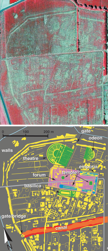
Ne emerge un quadro molto dettagliato: «Vediamo una cinta muraria
- descrive Mozzi - un teatro, un anfiteatro fuori le mura, la basilica,
il foro con il mercato, poi una strada principale connessa con la via
Annia; si vede inoltre un canale che taglia in due la città e va
in direzione della laguna. Considerando il livello del mare in
età romana - continua Mozzi - quel canale doveva essere connesso
con la laguna, inoltre era connesso con i fiumi e quindi rappresentava
un punto di raccordo tra sistemi fluviale e lagunare». A ridosso
delle mura, inoltre, il canale forma una porta acquea e le mura
diventano ponte. «Con dimensioni comparabili a quelle di
Pompei - spiega Mozzi - Altinum è la sola grande città
Romana nel Nord Italia e una delle poche in Europa che non è
stata sotterrata dalle città sorte successivamente, medievali e
moderne ed è per questo che possiamo vedere così bene le
strutture cittadine dell’epoca romana», si vedono
addirittura le case e le strade interne. «I nostri risultati
indicano l’esistenza di una complessa struttura urbana con varia
e spettacolare architettura che si è adattata alla
peculiarità dell’ambiente lagunare - si legge su Science.
Questi dati mostrano che i Romani riuscirono con successo a sfruttare
l’ambiente anfibio parecchi secoli prima che la città di
Venezia cominciò ad emergere sull’arcipelago in mezzo alla
laguna». C’è tuttora un lavoro in corso in accordo
con la Regione Veneto e la Sovrintendenza, spiega Mozzi, per verificare
lo stato di conservazione delle strutture nel sottosuolo, considerando
che Altino è stata ’smontatà e spogliata dei suoi
materiali preziosi per costruire la vicina Torcello e Venezia.
Un’opera di scavi sarebbe troppo complicata, conclude Mozzi, ma
questo lavoro e le nostre ricerche in corso permetteranno di capire
quanto c’è di intatto di questo importante patrimonio
storico e archeologico.
|
|
|
Ancient Roman City Rises Again
|
By Andrew Curry
ScienceNOW Daily News
30 July 2009
From the ground, a 100-hectare site just north of Italy's Venice
airport looks like nothing more than rolling fields of corn and
soybeans. But it's actually home to a buried Roman metropolis called
Altinum, considered the precursor of ancient Venice. Now, using
sophisticated aerial imagery, researchers have brought this city to
life once again.
Archaeologists have known for decades that Altinum, a Roman trading
center that thrived between the 1st and 5th centuries C.E., lay below
these farm fields. Raised 2 to 3 meters above the surrounding marshy
lagoon by centuries of human habitation, the city was approximately the
size of Pompeii. Its history could stretch back to the Bronze Age, and
it dominated the region for at least 600 years before it became a part
of the Roman Empire.
But all traces of Altinum's buildings have long since disappeared,
either stolen as building material or swamped by rising water levels in
the surrounding lagoon. So how to map a city with no visible ruins? In
July 2007, during a severe drought, Paolo Mozzi, a geomorphologist at
the University of Padua in Italy, and his team took aerial photos of
the site in several wavelengths of visible light and in near-infrared,
with a resolution of half a meter.
When the images were processed to tease out subtle variations in plant
water stress, a buried metropolis emerged. The researchers discovered
that the crops planted on the land were in different stages of
ripening, thanks to differences in the amount of water in the soil.
Lighter crops traced the outlines of buildings--including a basilica,
an amphitheater, a forum, and what may have been temples--buried at
least 40 centimeters below the surface. To the south of the city center
runs a wide strip of riper crops. They were growing above what clearly
used to be a canal, an indication that Venice's Roman forebears were
already incorporating waterways into their urban fabric.
In fact, Altinum's end may have been Venice's beginning. The first
century Roman historian Strabo mentions Altinum's importance: Its
location near both heavily traveled sea routes and along roads running
north to the edges of the Roman Empire made it a critical mercantile
center. But as waves of barbarians invaded, Altinum was a ripe target.
Finally, in the 7th century C.E., a Lombard invasion pushed the city's
beleaguered residents onto the defensible islands of the Venice lagoon.
Altinum was eventually abandoned entirely. Most of the ancient city's
stones were stolen in the Middle Ages to be reused elsewhere.
Land-reclamation efforts in the 19th century turned the area from marsh
into farm fields. "Altinum is unique because it was not built upon in
later times," Mozzi says. Previous archaeological excavations have
focused mainly on the city's necropolis, located outside the walls;
this is the first-ever glimpse of the city's layout.
Local officials are enthusiastic about the study, which will be
published in tomorrow's issue of Science. "Before what Professor Mozzi
has done, it was impossible to imagine the complexity and distribution
of the main buildings and structures of the municipium," Margherita
Tirelli, inspector of the Archaeological Superintendence of Veneto and
director of the National Archaeological Museum of Altinum, writes in an
e-mail.
Mozzi and his team are planning further survey work, including scans of
the area with a remote-sensing technology known as LIDAR, which will
help create a higher-resolution topographic map of the site. The team
also plans to sample soil at the site to see whether environmental
conditions, such as flooding or drought, might have contributed to
Altinum's abandonment. The images will help archaeologists pinpoint the
best locations for future excavation, Tirelli says: "They will help us
very, very much in our future work of conserving the ancient site of
Altinum. At the moment, we have a lot of hopes and plans but no money."
Articolo pubblicato
dalla Rivista Science
|
|
|